Tuesday 26 January 2016

D is for Diego

DIEGO Suarez – a huge natural harbour on the northern tip of Madagascar – is the setting for some of the climactic scenes of the book. It was also the final stage of my journey around Madagascar.

Welcome to Diego!

I reached the city in the late afternoon and have two particularly vivid memories of my arrival. The first was the dense perfume of ylang-ylang plants; the second was having a hot shower! By that point I’d been on the road for days and although I’d sometimes had the luxury of running water, that water had never been heated. In Diego I not only stayed in what was recognisably a hotel, it had decent plumbing. I can’t tell you how much I enjoyed that shower. Afterwards I sat on the veranda of my room which overlooked the Indian Ocean. Writing is often a miserable business but on occasions I can think of no better profession.

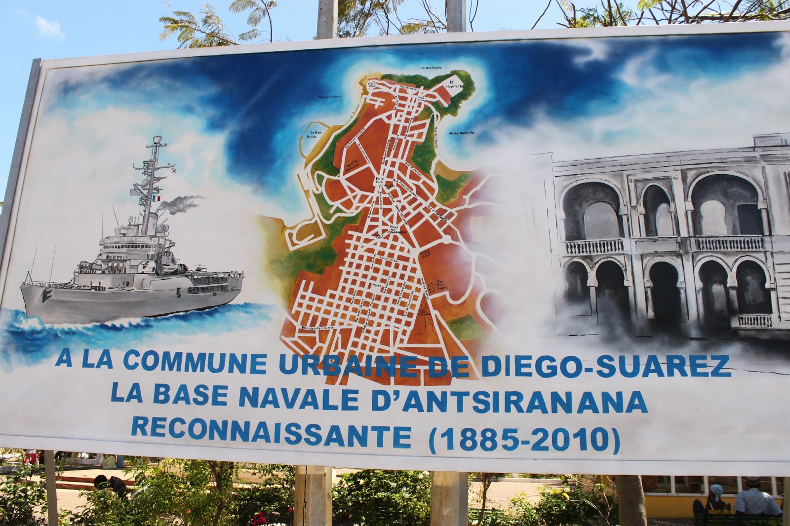
Diego Suarez was named after two Portuguese admirals: Diego Diaz and Fernando Suarez, which is rather forgiving given that on arrival in 1506 they murdered and enslaved the locals. Despite attempts to revert back to its native name of Antsiranana most people still call it Diego. It is a pleasant port city: a fusion of Indian, African and Arab influences. Bustling and lushly tropical. During my visit hot winds seemed to blow continually. Just outside the city are empty beaches of white sand and azure waves. But I wasn’t here as a tourist. On my first morning I had an appointment at the city’s naval base.

There’s been a military base on the site since the French established one in 1885. From my research for Afrika Reich I knew the Nazis wanted to build a naval fortress here (it’s specifically mentioned in the Bielfeld Memorandum, their blueprint for the continent if they had conquered it). Over the years this fortress had grown in my mind until it became a towering polygon of steel and concrete housing aircraft carriers, submarines and battleships. The reality was...er... rather different. Although the port impressed with its sheer size, it was utterly dilapidated, and with Madagascar being so poor its navy is hardly formidable.

Nevertheless, the Base Commander, the improbably named Randrianarisoa Marosoa Nonenana, was keen to give me a guided tour – and once again this walking the ground proved invaluable when I came to write the final scenes at Diego: from how the landscape tiers down to the water, to the palm trees sprouting among the barracks; the positions of the gun emplacements and the layout of the workshops.


Across the water there was also a huge runway – which gave me an unexpected motive for Salois’s mission. As an aside, in the months before my visit, the US military had been wanting to use the runway as a staging post for bombers to Afghanistan. The appearance of a strange foreigner fuelled all sorts of rumours amongst the Malagasy sailors. In the few hours I was at the base word got back to me that I must be a CIA agent casing the place out. The other alternative – that I was a British writer researching a book – was dismissed as too improbable.


D is also for DIE HARD


Did you get the reference? This is a clue
Many readers of the first book detected multiple references to DIE HARD. As I wrote at the time, none of these were intended, indeed to the best of my knowledge there’s no allusion to the film anywhere in Afrika Reich. Nevertheless people were adamant, so when I came to Madagaskar I thought I’d put an extended reference to the film in the book. Doubtless, this time round no one will identify it as such! Did you spot it?

M is for MANDRITSARA

On a map the journey from Antsohihy to MANDRITSARA looks nothing: 100 miles along Route 32. The reality is a bit more daunting. Although a paved road was built in the 1960s very little maintenance has been carried out since. The annual cyclone season has battered it for decades. We set out at 7am. In a few places the tarmac was fine, but mostly it was as pitted as the lunar surface, including several ‘potholes’ that threatened to swallow up our four-wheel drive. At one point our jeep literally disappeared beneath the surface of the road – something I now regret not photographing. The journey took seven hours – but whatever it lacked in speed was made up for by the sheer drama of the landscape.

Landscape on the road to Mandritsara

I should point out a small detail about the book and my research trip. The Madagaskar Plan is mostly set in April, during the rainy season. I travelled in September when it was dry because many of the roads are impassable during the wet months. So I had to imagine the landscape I saw not as gold and brown and taupe – but as a lush emerald.

Mandritsara is one of the most remote places I’ve ever visited. Even my guide, a native Malagasy with twenty years of tour experience, had never been there. On the long, torturous drive we stopped at a village and so unusual was it to see a tourist that everyone in the village (or so it seemed) wanted to say hello and shake my hand.

Finally, under grey skies and an oppressive heat, we reached Mandritsara. It sits in the Sofia Valley (see R is for...) and in the book is the location of a secret Nazi hospital that conducts unspeakable experiments. There is a real missionary hospital in the town – which is where I stayed during my visit (the town not being over-blessed with alternative accommodation). The hospital – with its courtyards and carmine brick walls – was to become the basis for the hospital in the book, though the latter is on a much bigger scale. I should also add that there is no connection between the two. Indeed the real one is a missionary hospital that does work for the local community and surrounding area. I was shown round by its administrator, Dr David Mann. I always feel humbled by people who give up their lives for the sake of others.

Part of the hospital, as seen from the top of its water tower

It was sobering to see the primitive conditions of the hospital in comparison to what we expect in the west. If ever you complain about the NHS or equivalent – you should come to a place like this. But enough moralising. The tour of the hospital prompted many unexpected ideas for the book. At the end I climbed to the top of the water tower and had a spectacular view of the valley as the sun began to dip. In the distance I could make out another complex of buildings and as dusk approached I went to visit. [Spoiler alert.] It turned out it was an abandoned colonial school from the 50s, and exploring it as the night descended, alone and with a vague sense of foreboding, I had a moment of inspiration for when Burton reaches the hospital at Mandritsara...


M is also for MICROCLIMATE

Later on in my trip I visited Montaigne D’Ambre national park. It has nothing to do with the book (though Salois does mention it towards the end) but since it is a couple hours drive from Diego, and since the chances of me returning are slim, I thought I’d take the opportunity to hike and camp there. One detail about the place I must share.

One of Montaigne D'Ambre's many waterfalls

Montaigne D’Ambre has a MICROCLIMATE, the park being enclosed by a ring of mountains; a microclimate much chillier than the surrounding landscape. I noticed it as soon as I entered the park – but more so as we left. By that point I’d been there three days, three days of cold rain and being wrapped up in T-shirt, shirt, hoodie, jacket, two pairs of socks and a hat. As we (guide, driver and me) left the park we passed out of the micro climate and in the space of no more than ten foot went from being cold to sweltering. It was like stepping through a barrier. We had to stop the jeep, pile out and strip back down to our T-shirts. One of the more bizarre experiences of my trip.


A is for ANTSOHIHY

From Tana I took a plane to Mahajunga (Mazunka in the book, where the radar station is). Internal flights – on the unfortunately named national carrier, Air Mad – are a hair-raising experience of propellers, turbulence and crazy pilots, but necessary given the size of the island. At Mahajunga I was met by my guide and driver who would be my constant companions over the next few weeks of travel; luckily we got on well.

Our first destination was Ankarafantsika National Park where I spent several days trekking through the jungle to get a sense of what it would be like for Burton and the other characters as they moved around the island. Particularly memorable was a night hike, the forest thick and loud with insects and tree frogs. As it happens, nearly all these journey scenes were cut from the book (word length again) but it was still a useful experience to understand the physical demands put on my characters.

Sculpture at the entrance of Ankarafantsika National Park

Next was the town of ANTSOHIHY, a ten hour drive from Ankarafantsika; we had to be there by dusk. Travelling on Madagascan roads is not advisable after nightfall, a combination of poor road conditions (and obviously no lighting), wild animals wandering into your path, and banditry. So we left first thing. In the year the book is set, 1953, the drive would have been through dense jungle but all the forest has long since been cut down. Deforestation is a major issue on the island. Several times on my journey I saw the land either side of me literally being slashed-and-burned. There’s something apocalyptic about travelling along roads bordered with fire.

Antsohihy, or Antzu as it is called in the book, is one of the key locations of the narrative. In reality, it’s a forgotten, nowhere place in the north-west of the island that merited only six lines in my guide book. Tourists rarely come here; it’s one of the most obscure places I’ve ever visited. I arrived at dusk to the most dramatic of sights. A lilac sky, growing darker by the second, and in the distance the ridge of a hill on fire (more slash-and-burn) giving the impression of a great sickle of flame around the town. It was an image I used at the end of Chapter 43.

With little tourism, there’s not much call for accommodation so my base for the next few days would be one of several dilapidated bungalows inside a compound – the closest Antsohihy has to a hotel. The first thing I remember about arriving at the place is the mosquitoes. I’m rarely bitten by insects but the second I stepped out of the jeep the air around me was electrified with them, my arms black and crawling... a detail I incorporated into the book. Another detail which you’ll recognise when you’ve read The Madagaskar Plan was my room: corrugated tin roof, breeze blocks painted white and behind a partition, a bucket of water that was my ‘shower’. Dinner was served in an outbuilding and I assumed I would be the only guest but as I entered I heard voices. English voices. It turned out that the BBC camera crew filming David Attenborough’s series on Madagascar was also in town.

There are no street maps of Antsohihy and wanting the scenes there to be as accurate as possible, the next morning I set out to draw my own. Since foreigners are so rare here, my guide felt uncomfortable leaving me by myself so together we explored the streets and backroads, sometimes on foot, sometimes in the jeep. It was punishingly hot. But the experience furnished me with a wonderful array of details that I could only have learnt by being there. There was the lie of the ground and how the whole town slopes down to the river; an old colonial mansion painted a vile acid green; the abundance of mango trees and great spewing fountains of magenta bougainvillea; a long, snaking road named after a man called Boriziny, though who he was or why the road had been named after him was lost to the inhabitants.

On the final day I made my way to the docks. Antsohihy is on the Analalava River which connects it to the coast. Years ago barges brimming with plantation crops made this journey. Now most of the agriculture has gone. The river is quiet, the docks rotting. And on a warehouse I came across some graffiti. I did try and think of some clever link between it and the end of this section, but the picture probably says it better:


A is also for ANKARANA

After Antsohihy I travelled to Mandritsara (which will be the subject of my next blog entry). Mandritsara is literally on a road to nowhere, so once I finished there I had to retrace my steps and spend another night in Antsohihy before heading north again to the ANKARANA Special Reserve. This doesn’t feature in the book but is worth mentioning for its geological rarity.

Ankarana is a limestone massif that rises out of the jungle. It is a strange and extraordinary landscape, riddled with crocodile caves and one of the few examples in the world of ‘tsingy’: protrusions of limestone that have been eroded by rainwater to form jagged pinnacles. Too sharp and delicate to walk on, you view them from above on swaying bridges that reminded me of that scene in Indiana Jones & the Temple of Doom.


T is for TANA

Standing where Hochburg stands

TANA – or to give it its full name Antananarivo (literally: the city of a thousand warriors) – is the capital of Madagascar. It’s a long journey there: London to Paris for the connecting flight, then eleven hours down and across Africa to the Indian Ocean and southern hemisphere. Arriving was not for the faint-hearted. The plane landed at what looked like an abandoned airport. Along with four hundred fellow passengers I had to hurry across the tarmac into a suffocatingly humid arrivals hall. There were no queues, just an interminable scrum to get through. Immigration documents had to be filled out by hand, in triplicate, and presented to two different desks in order to get my passport stamped. The diary I kept while travelling simply reads, ‘ABSOLUTE CHAOS’. However, no matter how wearing it was (the heat, the press of bodies, screaming babies, an hour to get to the front), it occurred to me that it would have been nothing compared to the bedlam millions of Jews would have faced arriving in Nazi Madagaskar.

Next morning I began my exploration of Tana proper. I was staying in the suburbs and to get to the centre had to drive past shanty towns and brick factories, paddy fields, and canal banks with literally miles of washing laid out to dry on them. Tana reminded me of many big Africa cities: overcrowded, chaotic and slightly shabby, a bricolage of colonial architecture and more recent concrete blocks. It was also full of colour and a vibrancy that cities in the developed world just don’t possess. The lower town is truly labyrinthine, navigation around it made all the harder by the fact many streets don’t have names or that the names change regularly depending on which dictator is in power.

My most vivid memory is the main marketplace, especially the butchers where sausages and great racks of zebu rib (the local cattle) hung beneath red canopies, dripping blood and buzzing with flies. There was no sign of any refrigeration. I’ll leave the smell to your imagination.


Tana is built on a twelve hills, the highest of which is crowned with Queen Ranavalona I’s palace. Erected in the mid-19th century, it was destroyed by fire in 1995, leaving just the stone shell and has been in a state of permanent renovation since. From here I had a spectacular view across the plains as they shimmered in a heat haze. A warm breezed licked my face... just the way it does when Hochburg stands in the same spot in Chapter 16. The palace was the model for Globus’s headquarters in the book, not least because its rocky foundations are steeped in blood. Ranavalona, known as ‘the wicked queen’, was notorious for hurling those who displeased her off the walls of her palace. It seemed an appropriate base for the SS.


T is also for TAFT

[Spoiler alert.] One of the arcs that runs through the trilogy is America’s involvement in Africa: from disengagement in Afrika Reich through to being a full player in Book 3. America’s role in the world order is a key part of the plot in Madagaskar. For this I needed a president who was isolationist but not slavish so, as well as one with an ambiguous attitude to the fate of the Jews. At first I thought of making up a character, but given that most of the historical figures in the book are real, I felt obliged to do the same with my president. So I started scouring all presidential candidates and hopefuls of the 1940s and early 50s.

The biggest difficulty with this was how real history affected my choices. For example, Eisenhower became president partly on a war-hero ticket; other candidates were popular because they were tough on Communism, a stance that makes little sense in my world. I therefore had to disentangle these elements from my selection. Luckily, one figure soon came to the fore: Robert A. TAFT, a senator from Ohio and son of William Taft, the 27th President.


Taft had narrowly missed securing the Republican Party’s nomination for president against Eisenhower in 1952, so was a highly credible possibility given my altered timeline. Taft had another advantage. He died in July 1953 – i.e. three months after the events of Madagaskar – so if the narrative for Book 3 changes I have an excuse to ditch him!

Saturday 23 January 2016

T(1) is for TRAVEL, an introduction

Blink... and five months have passed since I last posted an entry on this blog. Where does the time go? It’s quite shocking the speed at which life passes. Anyway, I’m soon to be moving on to pastures new so I’m going to make a determined effort to finish this blog. Expect an entry a week now till it’s done. This new determination is going to start with the TRAVEL I undertook for The Madagaskar Plan.

One of the things that disappointed me about the first book was that I never visited the places I was writing about (see Q is for...). Mostly this was because they were too dangerous. Although Madagascar is one of the poorest countries on the planet, it is safe; so for the second book I was determined to travel there and walk the same ground as my characters. There’s something about being in the real locations that gives you an edge over just reading about them: it’s understanding the topography from a specific point; the hue of the light at sunset; the smell of the earth. All details you could never imagine.


Another reason for making the trip was that some of the locations in The Madagaskar Plan were so obscure there’s very little information about them to be found anywhere, either on-line or in specialist libraries. Going was the only way of knowing.


Early on in the plotting of Madagaskar I knew Burton would follow a certain route and I wanted to travel it myself. So I’m going to dedicate several entries in this blog to the places I visited, starting with Tana, one of the key locations for the exchanges between Hochburg and Globus, the governor of Madagaskar.

Before then you can get a preview of my research trips in this piece I wrote for Bookbrunch:

Click here to read on...